
Main Circlestone Map
Digging is not prohibited in the Wilderness Area, so the team was careful to leave the site undisturbed. There are many historic ruins in the Superstition Wilderness. When visiting, please leave them just as you found them. Arizona's wilderness areas are national treasures; visitors must share responsibility for preserving these unique natural and cultural resources.
Circlestone Article
The Circlestone Ruin is an ancient stone circle deep in the heart of the Superstition Mountain Wilderness Area. The Circlestone Research Project was an unique opportunity for undergraduate students to actively participate in original research. Students collected field and archival data, analyzed the data and participated in the professional presentation of their findings.
The Circlestone field expedition took place from February 15th through February 20th, 2006. Four students from MCC at the Red Mountain campus: Jennifer Kaufmann (Biology), Jared McBride (Mathematics), Dan Hammerl (Communication), and Charles Miller (Geology) accompanied Red Mountain faculty Bruce Peterson (Communication) and Dennis Wilson (Biology) into the Superstition Wilderness Area to collect surface measurements and biological data at the ruin. In addition, four other students assisted in website development, archival research, GIS mapping and graphic presentation: Chelsey Thievin, Teresa Baker, David Black and Danielle Spagnuolo.
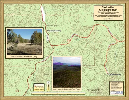
The Circlestone Trail Map
The Project Team hiked in using Forest Trail #109 from the Rodgers Trough Trailhead, just 5 ½ miles south of the site of their base camp. The map above shows the site of the base camp just north of the Reavis Ranch homestead site which is in a meadow bordered by apple trees and the camp’s relationship to the site of the Circlestone Ruin. The hike from the base camp to the ruin is just over 2 miles and climbs to a thousand feet. The map shows the path of the Circlestone Trail from Forest Trail #118 (The Fireline Trail) to the Ruin. The Project team mapped this steep segment of trail; we believe this is the only published map of the trail to the ruin.
The Solar Azimuth Map
One of the first questions everyone asks when confronted with the Circlestone ruin is, "Was the ruin some kind of calendar akin to Medicine Wheel, Wyoming or even Stonehenge?" There does appear to be possible sun alignments suggested after accurately mapping the ruin.
Satellite imagery shows the flat portion of the east wall of the ruin is very close to a north/south alignment. Earlier maps had a 14-degree declination miscalculation in their representation of the ruin. The 1984 and 2003 maps show the flat side of the circle at a NE/SW angle (See the upper left corner of the main map; the first map to the left in this series). Because of this miscalculation, astronomical alignments did not appear that likely. A 2003 Spring Equinox sunset photo did suggest a horizon alignment. The sun sets directly on top of Tortilla Mountain in the photograph on the above Azimuth map, which was taken from the ruin on March 21, 2003. With the use of satellite photos to create the 2006 Project maps, solstice alignments now appear probable. Solstice sunrises may have been marked or measured by the straight portion of the east wall; the interior east spoke appears to roughly align with the equinox sunrise.
No one knows who built Circlestone or when it was built. Speculations include various Native American groups as a ritual site, the Spanish or Mexicans as a sheep corral, and even a Celtic circle built by Elijah Reavis the famous Hermit of the Superstitions. The geographic position of the ruin and the apparent astronomical alignments now imply that the ruin was most likely a Native American site akin to a Medicine Wheel. The next map in this series, the “View Window from the Circlestone Ruin,” demonstrates a possible relationship to the Hohokam civilization.
The Surrounding Ruins Map
Prehistoric Ruins abound in the Superstition Mountain Wilderness Area. The ruins located around Circlestone appear to be predominately Hohokam and Salado. Pottery shards and tools are present at many ruins, and most are habitations. Petroglyphs can be found throughout the wilderness.
The sites plotted on this map are all recorded in the Tonto National Forest Archeological Archives. There are surely many more, since most that have been recorded are near trails. The trails in the Superstitions probably follow routes used by ancient people. Therefore, the habitations depicted here are most likely representative of geographic habitation patterns.
The US Forest Service defines a Wilderness Area as: "an area where the earth and its community of life are untrammeled by man, where man himself is a visitor who does not remain." Wilderness is a modern idea. Clearly the upper Superstitions were once the home of many people.
Today, disturbing any historic or prehistoric site is not prohibited in the Wilderness Area, and visitors have a serious obligation to leave all sites undisturbed. Adopt a NO TRACE ethic in our wilderness areas.
The Wall Heights Map
Stacy Peterson, an Honors Program math major, calculated the volume of the fallen rock to estimate the original height of the outer circle and the spoke walls. The map indicates the average original wall heights of different sections.
The Circlestone View-Window Map
A Hohokam Ruin?
Looking West Toward the Red Mountain Campus and Phoenix
The Circlestone Ruin is geographically placed on a knoll just below the summit of Mound Mountain, the highest point in the Superstition Mountains. Mound Mountain is 6266 feet in elevation, and Circlestone is at 6010 feet. Looking west from the ruin, one can not only view the equinox sun set on Tortilla Mountain (See Azimuth Map), but you also look directly down on the city of Phoenix, 45 miles away.
The city of the fiery bird has arisen from the ashes of the Hohokam civilization. This map shows the view window between the Usery Mountains and the Superstition Mountain onto the desert basin. The ancient Hohokam pueblos and their amazing irrigation system (much of which is still in use by SRP today) is layered over the metro street grid. The photo in the upper left-hand corner of the map was taken in 2003 and shows Tempe Town Lake reflecting in the sun. Unfortunately, pollution obscures the Phoenix valley most of the time today.
The Red Mountain campus of Mesa Community College is also centered in the view window. The project team was unable to attempt signaling between the campus and the ruin, but without modern light pollution, the signaling between Circlestone and the Hohokam's Pueblo Grande at night would have been easily possible. The half-circle structures on the west side of the ruin (see Azimuth Map) may have been signal fire structures, but without digging, there is no way to confirm that speculation. Whatever the case is, the Circlestone Ruin is strategically placed to see down into the Salt River Valley onto the desert basin.
First Paradise Overlook Map (by Jake Colpitts)
While researching the Tonto National Archeological Archives to identify the recorded ruins within a 5-mile radius of Circlestone, History student Chris Allen found another stone circle recorded as "Paradise Spring Overlook." The circle is 70 feet in diameter with a stone pile in the center. It’s about half the diameter of Circlestone, and the walls are not nearly as thick or tall. It is labeled "Paradise Overlook" on this map. The site was recorded by Charles Vernon on 4/15/93. In his report, he wrote: "Site is very similar to the well-known Circlestone site to the southeast, but not nearly as well defined. . . . Similarity to Circlestone indicates the possibility that it, too, was a ceremonial site."

Paradise Overlook Stone Circle Map
The site data collected for this map was collected on an expedition that occurred March 2012. Students, Peter Gomer, Brandon Barba and Professor Bruce Peterson, entered the wilderness area at the Roger's Trough Trail Head. They met Charles Miller, one of the original 2006 Circlestone Expedition team member, and his wife Vanessa at the ruin three days later.
Using the measurements collected by the team and a Google Earth image, the project produced this GIS vector map. The accuracy of Jake Colpitts' drawing made by pacing measurements and site sketches is quite amazing. The exact wall line on the west side of the circle under the juniper trees is difficult to ascertain.
Printable Paradise Overlook Circle Map
Paradise Overlook Data Sheet